
Sugar Grove road cut: Chabazite Rockhounding in Pendleton County, West Virginia
- Mineral reported
- 1
- Elevation
- 1,940 ft
- Best months
- February to December
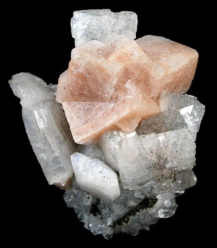
The Sugar Grove Basalt is one of the few zeolite localities in the central Appalachians, an Eocene amygdaloidal basalt dike-sill about 45 million years old that intrudes the Devonian Millboro Shale south of Sugar Grove. Its amygdules yield chabazite (including the rare phacolite variety) along with analcime, natrolite, thomsonite, mesolite, phillipsite, and harmotome, a suite far more typical of Oregon or New Jersey than of West Virginia. The small amygdule size makes it primarily a micromount locality, prized by collectors who work the weathered basalt for crisp, gemmy crystals. Reported finds include chabazite. Below: coordinates, access notes, nearby spots, and trip-planning links.
Plan your visit
Generally open to casual rockhounding
- County
- Pendleton County
- State
- West Virginia
- Nearest road
- Sugar Grove Road
- Postcode
- 26815
- Coordinates
- 38.48401, -79.32671
Coordinates are approximate. Confirm the exact ground in the RockHoundR app, where land overlays show which agency manages the area.
Land & collecting status
Generally open to casual rockhounding
Most public-tagged spots sit on BLM, U.S. Forest Service, or other federal land where reasonable hand collecting of common rocks and minerals is allowed. Confirm posted rules and active mining claims before you dig.
Access note: The dike is exposed in a road cut along a county road roughly 5.5 miles south of Sugar Grove. Road cuts sit on highway right-of-way, an area of legal gray zone in West Virginia, so surface-collect loose weathered material only, do not dig into the bank or dislodge anything above head height, and park well clear of traffic. Confirm you are not on the adjoining private land.
Public-land rules vary by agency, season, and field office. The RockHoundR app pulls live BLM, USFS, NPS, and tribal overlays so you can see exactly which agency manages the ground at this spot.
Best time to visit Sugar Grove road cut
Comfortable months (45 to 90°F highs)
Best months: February to December. Typical highs run 84°F in midsummer and 43°F in midwinter, with winter lows near 22°F.
Climate normals: NOAA 1991-2020 monthlies, FRANKLIN 2 NE station (13 mi away).
Geology at Sugar Grove road cut
This spot sits on Brallier Formation, mapped as shale and siltstone that formed roughly 420 to 360 million years ago. Sedimentary rock like this erodes unevenly, so the most productive collecting is typically along fresh cuts, badland slopes, and active drainages.
- Mapped unit
- Brallier Formation
- Age
- 420–360 Ma (Devonian)
- Rock types
- shale and siltstone
- Elevation
- 1,940 ft
Geologic mapping via Macrostrat and the underlying state geological survey maps (CC BY 4.0). Bedrock at the surface can vary within a mapped unit.
Today's weather
Is today a good day to go?
The app shows live weather, recent rain, and a daily rockhounding score for Sugar Grove road cut.
Get the appSources & verification
Spot details combine the public RockHoundR location dataset, normalized mineral labels, agency land-status checks in the app, and community submissions. Coordinates are approximate until verified in the field.
- West Virginia Geological and Economic Survey
- Monongahela National Forest
- West Virginia State Parks rules
- Community submissions reviewed against published agency rules
Found at Sugar Grove road cut
Each name opens all spots that produce that material; the encyclopedia link opens the full ID and field guide.
Nearby rockhounding spots
Other rockhounding spots within driving distance of Sugar Grove road cut.
- FranklinPendleton County, West Virginia · 12 mi awayChert, Smoky Quartz, Quartz
- Judy GapPendleton County, West Virginia · 17 mi awayCalcite, Dolomite, Smoky Quartz
- Smoke HolePendleton County, West Virginia · 26 mi awayGeode, Gypsum, Pyrite
- South Fork MountainGrant County, West Virginia · 30 mi awayHematite
- HarmanRandolph County, West Virginia · 31 mi awayCalcite, Dolomite, Quartz
- Deer CreekPocahontas County, West Virginia · 32 mi awayGeode
- Sitlington CreekPocahontas County, West Virginia · 33 mi awayGeode
- Knapp CreekPocahontas County, West Virginia · 35 mi awayGeode
Across the state line from Sugar Grove road cut
Sugar Grove road cut is close enough to the West Virginia border that the next-closest rockhounding spots are in a neighboring state. Worth knowing if you are already on the road.
- Chestnut RidgeBath County, Virginia · 29 mi awayQuartz
- SpottswoodRockbridge County, Virginia · 37 mi awayQuartz
- South Fork Shenandoah RiverRockingham County, Virginia · 38 mi awayQuartz
- Tye River GapRockbridge County, Virginia · 42 mi awayEpidote, Unakite, Beryl
- Moormans RiverAlbemarle County, Virginia · 42 mi awayEpidote, Jasper
- Big Mary's CreekRockbridge County, Virginia · 42 mi awayUnakite
Sugar Grove road cut FAQ
Where is Sugar Grove road cut?+
What rocks and minerals can you find at Sugar Grove road cut?+
Is collecting allowed at Sugar Grove road cut?+
What tools should I bring to Sugar Grove road cut?+
When is the best time to visit Sugar Grove road cut?+
How do I get to Sugar Grove road cut?+
More rockhounding in West Virginia
See all 41 West Virginia spots →
Open Sugar Grove road cut on the map
Use the RockHoundR app for live land overlays, weather, geology, directions, and saved finds.


